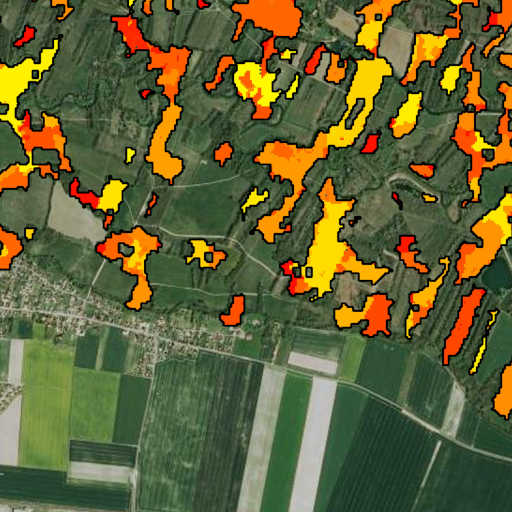
The map of forest clear-cuts in mainland France, generated from Sentinel-1 radar data using a radar change ratio method, provides a near real-time assessment of clear-cut areas at a 10-meter pixel size and a minimum mapping unit of 0.1 ha. The map allows to accurately detect clear-cuts with a precision of 99.4% and a recall of 80.9%, validated using 967 reference plots. This publicly accessible map offers detailed insights into the dynamics of clear-cutting across France's temperate forests. It reveals significant regional variability and a notable concentration in private forests, which exhibit seven times more clear-cutting than public forests.
Data Files (Version 3.0.1):
- `forest-clearcuts_mainland-france_date_v3.tif`: Estimated date of clear-cuts. Pixel values are in the format YYDDD, where YY represents the estimated year of the clear-cut (between 18 and 25), and DDD represents the day of the year (between 1 and 366).
- `forest-clearcuts_mainland-france_prob_v3.tif`: Probability of clear-cut occurrence (expressed as a percentage).
Version history:
- 1.0: First global mapping of mainland France (January 2020 - July 2023). This dataset is the result of the detection method published in the JSTARS article cited above.
- 2.0: Extension of the detection period (January 2018 - August 2024) and modification of certain aspects of the algorithm (refinement of the snow mask, adaptative Radar Change Ratio computation). Version 2.0 is more conservative than version 1.0, with fewer detections, fewer commission errors and more omissions.
- 3.0: Update of the detection period (January 2018 - February 2025) and modification of certain aspects of the algorithm (analytic snow mask, adjusted thresholds for different forest types, adjusted Radar Change Ratio computation). Version 3.0 is more conservative than version 1.0 but less conservative than version 2.0, and is therefore considered a compromise between version 1.0 and version 2.0.
- 3.0.1: Update of the detection period (January 2018 - September 2025)
For a detailed description of the method, results, and version history, please refer to the associated publication:
Mermoz & al., 2024[1]